During this two-week trip, I’ll cover about 2,800 miles. Ninety-nine percent of the time, I’ll be in Colorado; that’s where the Pass-a-Paloozas™ are. Today will include the one percent that’s not in Colorado: a 28-mile stretch of road in northern New Mexico.
One of my ski school friends, Sandy, who’s from Albuquerque, has a sticker on his locker I’ve always enjoyed: “New Mexico. It’s Not New. And It’s Not Mexico.”
OK, New Mexico. See you in about two hours.
We begin the day riding east into the morning sun, toward Del Norte, 15 miles away. Del Norte, population 1,500, gets its name from the Rio Grande del Norte, “large river of the north” in Spanish. The town sits at 7,884 feet, on the banks of the Rio Grande, surrounded by the Rio Grande National Forest.
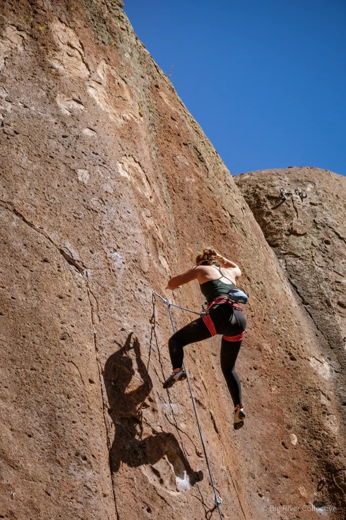
Just outside Del Norte is Penitente Canyon, once a worship area for the devout Catholic sect Los Hermanos Penitente. It’s now a worship area for devout rock climbers from around the world. Featuring more than 300 sport-climbing routes, the canyon has been featured in Climbing magazine. A penitent is a practitioner of ritual penance, typically Catholic; they’re known to practice self-whipping and other forms of torture, during Holy Week.
Coors Barley in Monte Vista
We soon roll through Monte Vista, Spanish for “mountain view.” Monte Vista is bordered by the Sangre de Cristo (“blood of Christ”) range to the east, and the San Juan Mountains to the west. The town is in a high-plains valley in the San Luis Valley. Here, farmers raise potatoes, alfalfa and carrots, but the area has become famous for another agricultural product – Coors barley. The world’s largest single-site brewery, Miller Coors, based in Golden, relies on the farms around Monte Vista to produce special barley for its beer.
The Monte Vista National Wildlife Refuge is one of the area’s top attractions. Established by the Migratory Bird Conservation Commission in 1953, the wetland habitat provides a safe place for wildlife, especially migratory birds. In March and September, 20,000 migrating Sandhill Cranes use the refuge as a stopping point. One of the best times to visit the refuge is during the annual Monte Vista Crane Festival held each March.
Fifteen miles beyond Monte Vista, we arrive in Alamosa, our first stop of the day. With a population of 10,000, Alamosa is the commercial center of the San Luis Valley, and home to Adams State University.
Alamosa was established in 1878 by the Denver & Rio Grande Railroad, and quickly became an important rail center. The railroad had an extensive construction, repair, and shipping facility in Alamosa for many years. Every June, Alamosa hosts “Summer Fest on the Rio,” a festival that has arts and crafts, musical entertainment, and activities for the kids. Cottonwood trees are abundant in the area, which may explain the town’s name; Alamosa, in Spanish, means “of cottonwood.”
Next town on the horizon is Antonito, Spanish for “highly praiseworthy.” Antonito, population 650, began as a sheep herding camp known as San Antonio Junction. The junction referred to its proximity to the Conejos and San Antonio rivers.
When the Denver & Rio Grande Railroad built its line south from Alamosa, the town was renamed Antonito and became an important town on the rail line. Antonito has a number of unique buildings, including a historic railroad depot that’s one of only a few lava rock depots remaining in the US.
The town is known for its many murals, most of them painted by Fred Haberlein. He received his formal training from a community of Benedictine nuns in Antonito. His work can be seen as far away as Quito, Ecuador, and as close to home as Carbondale. Fred’s most recognized public art in Carbondale is the 9-foot-by-48-foot “Interconnected Web of Life,” depicting a scene along the Crystal River, painted on the west side of the Dinkel Building.
He went on to complete 80 murals in the San Luis Valley before moving to Glenwood Springs with his wife, Teresa Platt, in 1988. For 18 years, Haberlein taught “Drawing on the Right Side of the Brain” at Colorado Mountain College. He died at his home in the Roaring Fork Valley in 2018, at the age of 74.
Pass-a-Palooza™ … La Manga Pass: 10,230 feet
We turn west in Antonito. It’s a half-hour ride to the first Pass-a-Palooza™ of the day, La Manga Pass. For some reason, La Manga means “the sleeve.”
To get to the sleeve, we follow Colorado Highway 17, along the Conejos River. In Spanish, Conejos means “rabbits.” The river took that name in 1861 because of the area’s large rabbit population.
Pass-a-Palooza™ … Cumbres Pass: 10,222 feet
We dip down for a few miles, then rise up to the next pass: Cumbres, which means “summit” or “peak” in Spanish. OK, that makes sense. Cumbres and La Manga Passes are rarely closed in winter. The road over Cumbres Pass follows the same route as a railroad line built in the early 1880s by the Denver & Rio Grande Railroad as part of its extension from Alamosa to Durango.
Both Cumbres and La Managa Passes are in the San Juan Mountains.
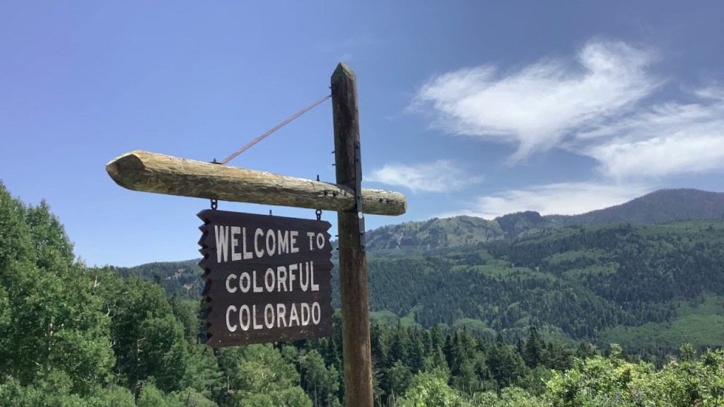
New Mexico, Here We Come!
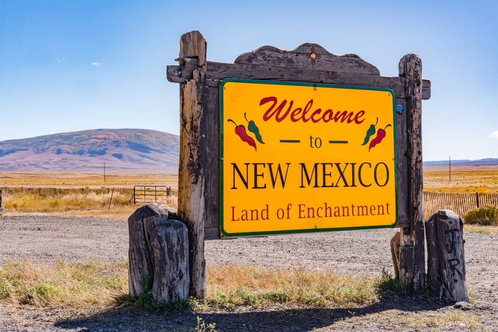
My One Percent has finally arrived. It isn’t New. And it isn’t Mexico. We’re officially in the Land of Enchantment.
Four miles southwest of Cumbres Pass, we cross the border into New Mexico, as the road morphs from Colorado Highway 17 to New Mexico Highway 17.
Six more miles and we’re in Chama, a New Mexico village of 900 on the Rio Chama river. Today, Chama is Spanish slang for “bro” or “dude,” though that’s not the meaning town fathers had in mind. They named it after the Rio Chama.
Colorado, Here We Come!
We leave Chama, and head back toward Colorado, where we’ll spend the remainder of the trip.
Our 28-mile New Mexico adventure is over, seemingly as soon as it began. The first Colorado sign of life we see is Chromo, which has a post office, but little else. Chromo takes its name from nearby Chromo Mountain.
There’s nowhere to stop in Chromo, so we power on toward Pagosa Springs, 20 miles ahead. We arrive at the town’s eastern edge, a few miles from downtown. Pagosa Springs was first discovered by Native American Ute Tribes, who called it Pagosah, meaning healing or boiling waters.
Following a break to adjust fluids, we press on toward our final pass of the day.
Pass-a-Palooza™ … Wolf Creek Pass: 10,857 feet
I experienced Wolf Creek Pass and its crossing of the Continental Divide last week with Sarah and Brittany. So, I’ll just remind you that there’s both a pass and ski area 20 miles ahead. And I’ll remind you that Wolf Creek Pass is yet another Top Ten list Honorable Mention.
If you feel cheated and want to read all about Wolf Creek Pass, click here to view last week’s post, and scroll down to the section about Wolf Creek.
From the pass, we descend 2,550 feet over 18 miles before reaching tonight’s destination, South Fork. If that sounds familiar, it’s because this is our second night in South Fork. We again are on the lookout for reminders of Bobby Ewing or his brother, JR.
To see today’s route from South Fork, over three Pass-a-Paloozas™, into New Mexico for 28 miles and back to South Fork for Night Two, click here.
***
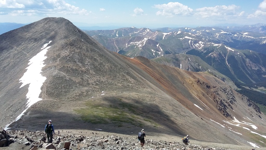
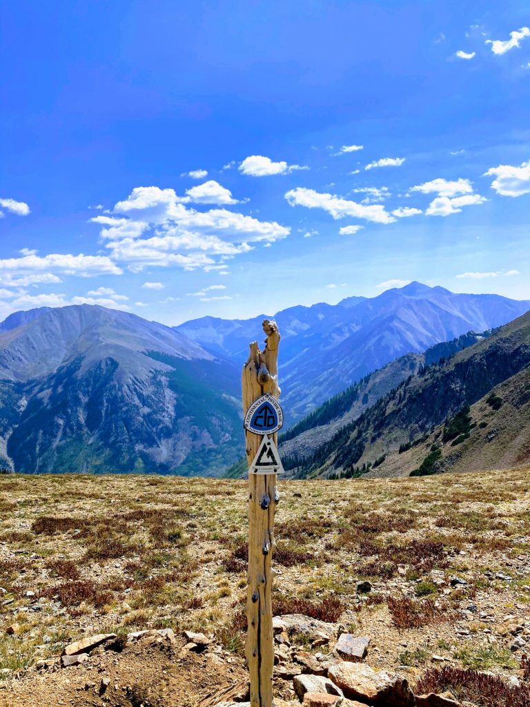
Today’s Not Quite Pass-a-Palooza™… The Continental Divide Trail
Two of the passes we crossed today, Cumbres and Wolf Creek, share a common distinction. They’re both on the famous Continental Divide Trail.
The highest point on that trail is 14,278 feet, and it’s 3,100 miles long.
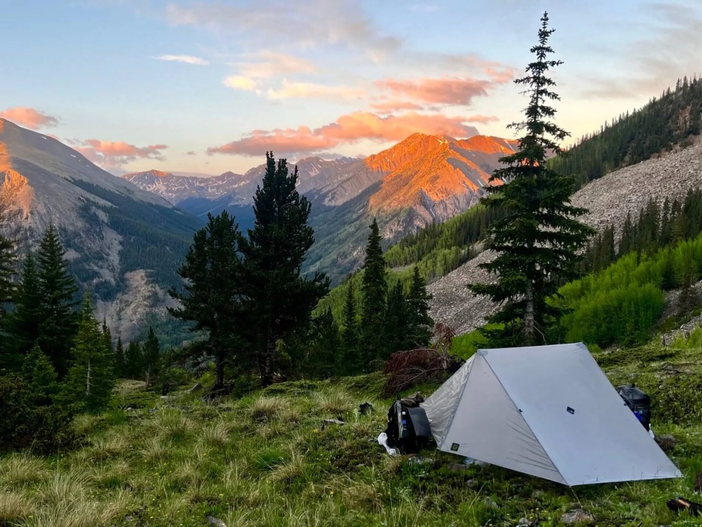
So, the Continental Divide Trail gets the honor of being today’s Not Quite Pass-a-Palooza™. The CDT, as it’s called, traverses 735 miles of the Rockies. In a normal year, snow covers most of the trail through May, and sections of it well into June. Plan accordingly.
The average elevation of the trail in Colorado is 10,000 feet above sea level. Along the way, it crests the highest summit on the Continental Divide: Gray’s Peak, a stunning 14,270 feet above sea level.
Heading north from the New Mexico – Colorado border, where we rode earlier today, the CDT soon enters the Weminuche Wilderness, Colorado’s largest designated wilderness area, situated in the Rio Grande and San Juan National Forests.
Other alpine highlights along Colorado’s Continental Divide Trail include the Collegiate Peaks and Rocky Mountain National Park, both boasting unparalleled views of glacial lakes, deep rounded valleys, and sharp, snow-capped summits.
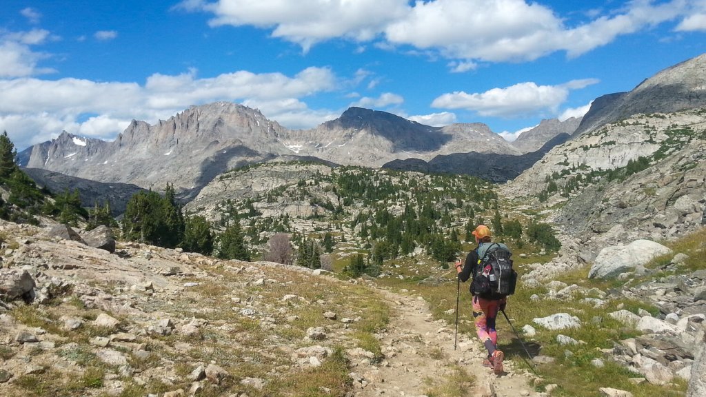
Unlike the other Not Quite Pass-a-Paloozas™, you won’t be able to drive the CDT. Sorry ’bout that. You’ll need to get off your butt, put on some sturdy shoes, get yourself in shape, and start hiking. You can use your car to get to the trail; you’ll just need to park it and walk from there.
For example, there’s a Continental Divide kiosk at Wolf Creek Pass, which we just rode over an hour ago. Just past the kiosk, take a dirt road, and in a mile and a half, you’ll be at a parking area, where you can begin your hike.
The CDT occasionally goes through towns, where you can enjoy a brief return to civilization, stock up on necessities, and have a sit-down meal before pressing on. Chama, New Mexico, where we were a few hours ago, is one of the towns that the trail crosses. If you run into someone at Fina’s Diner, they might be fresh off the trail, and might appreciate a conversation, a hug and an ice cream cone.
In Colorado, the trail goes through Pagosa Springs and South Fork, two places we saw today. The CDT also goes through these Colorado towns I’ve visited on this trip: Silverton, Lake City, Creede, Twin Lakes, Leadville, Silverthorne, Breckenridge, and Salida. I probably should have named this trip the Continental Divide Harley Trail Ride.
Some notable points on the CDT in Colorado include the shoulders of Mount Elbert and Mount Massive, two of Colorado’s highest fourteeners; the Collegiate Peaks Wilderness; and the Cumbres and Toltec Scenic Railroad, which we crossed today near Cumbres Pass.
The CDT is one of America’s National Scenic Trails, along with the Pacific Crest Trail, the Pacific Northwest National Scenic Trail, and several others.
The establishment of the Appalachian Trail and the Pacific Crest Trail inspired proposals to create a Continental Divide Trail. You may remember the Pacific Crest Trail from the 2014 movie, Wild, starring Reese Witherspoon. The first section of the proposed Continental Divide Trail was laid out in Colorado in 1962 by the Rocky Mountain Trails Association.
Thru-hikers of the Continental Divide Trail, the Appalachian Trail and the Pacific Crest Trail can achieve what is known as the Triple Crown of Hiking. A thru-hike is doing the trail, end-to-end. Most people aren’t that ambitious, and don’t have that much free time. They generally do smaller portions of the CDT, then go back to work, or to school, or whatever it was they were doing.
Those ambitious enough to try thru-hiking usually begin the hike in April in New Mexico, hike northbound, and finish at the Canadian border in August or September. Colorado was overwhelmingly voted the most difficult state for thru-hikers in a survey of those who tried it.
The trail is generally marked with signs, letting hikers know they’re on the right track.
A good hiking pace on the CDT is 24 miles a day. Ooooh, that doesn’t seem so hard. One mile every hour.
If you do the whole thing, end to end, allow five to seven months. Before you start, you should know how to read a map, use a compass, manage resupplies, and deal with limited water. There’s a lot of helpful information out there for those who want to give it a whirl.
Time to get moving. You’re not getting any younger, or better looking.

Gary your history and geography lessons mixed in with some riding and great phptos are a true pleasure to read thank you!!!
LikeLike