
Today, we’re heading to New Mexico. We have Randy Suhr to thank for that.
Last year, as we were planning this trip, I asked Randy what it would take to get him to come along. After all, he lives in Seattle, about 1,200 miles northwest of Durango, where our day is starting. The upper left-hand corner of the US is a long way from anything.
“Why don’t we go to New Mexico?” Randy said last fall.
“OK,” I replied. “If we do, are you in?”
He said Yes.
So, we added Taos to our itinerary.
Taos, New Mexico, is a historic and artistic community at the end of today’s 277-mile journey. It would have landed Randy just a bit further from home. By tonight, we’ll be almost 1,500 miles from his house in Seattle.
Unfortunately, somewhere between trip planning and trip departure, Randy encountered medical issues that kept him from joining this year’s trip. We miss him every day.
As we leave Durango this morning, we take some solace knowing Randy is along in spirit.
Thank you, Randy. We’ll be in New Mexico for dinner, all because of you.

Chimney Rock National Monument
From Durango, we begin our day by heading east on US Highway 160.
Thirty miles ahead, we cross the Piedra River, which flows for 40 miles through several box canyons in the San Juan Mountains. The Piedra name stems from the Spanish word meaning “rock.”
It’s feeling like a rocking day. Our next point of interest is Chimney Rock National Monument, just ten miles past the community of Piedra, population 31. The 4,726-acre monument includes a massive rock structure, and an archaeological site that’s been on the National Register of Historic Places since 1970. Former President Barack Obama made it a National Monument on September 21, 2012.
The monument is surrounded by the Southern Ute Reservation. Chimney Rock itself, 315 feet tall, is over 535 million years old.
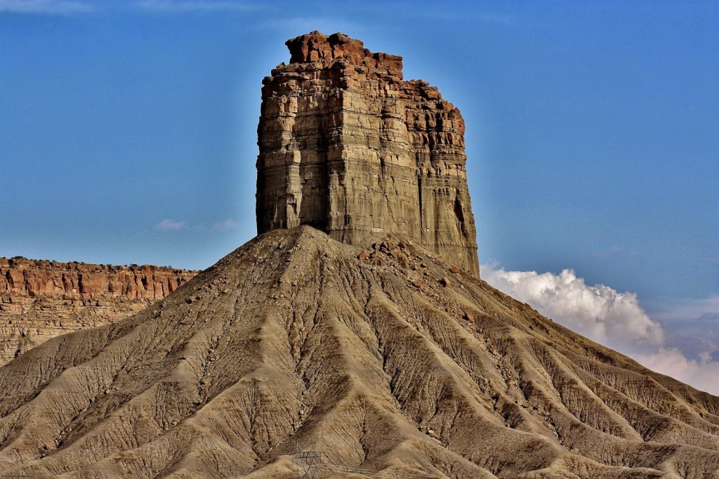
The national monument is a sacred place with spiritual significance to two dozen modern-day native tribes. Chimney Rock preserves 200 ancient homes and ceremonial buildings, some of which have been excavated for viewing and exploration.
Pagosa Springs
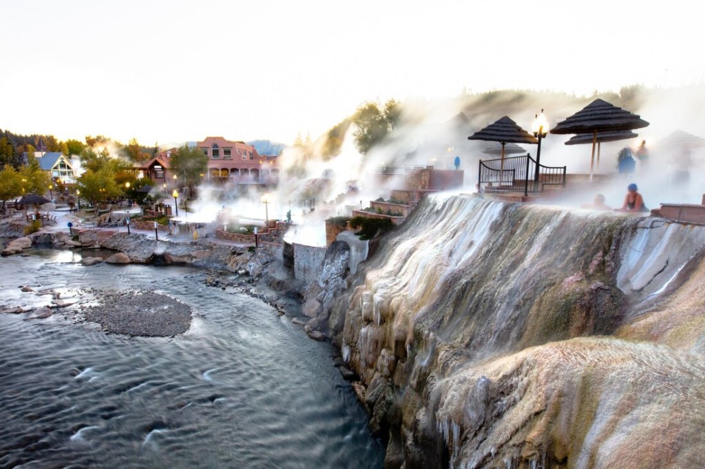
About 20 miles east of Chimney Rock is the town of Pagosa Springs, population 2,000. The town is named for a system of hot sulfur springs located there, which includes the world’s deepest geothermal hot spring.
The hot springs drive the town’s thriving tourism industry. Pagosa Springs occupies a prominent place on Colorado’s hot springs loop. The town has several resorts with mineral-rich, thermal hot springs, located right on the San Juan River. Water from the “mother” spring is about 144 degrees Fahrenheit. Mix that with some river water and you’ve got yourself a relaxing experience. The tourism marketing people call it “water-based wellness.”
Pagosa Springs is experiencing a substantial influx of second home owners. Roughly 60 percent of area private properties are owned by non-residents.
For those visitors, like us, just passing through town, you can get a day pass at several of the resorts to soak your tired bones. At The Springs Resort, $59 gives you access to 20 pools. It’s tempting, but we still have almost four hours of riding before arriving in Taos. The open road beckons.
Entering New Mexico
We turn south on US Highway 84. About 20 minutes later, we transition from Colorado to New Mexico. Are you happy, Randy?
New Mexico is new for all of us. I made a cameo appearance here nine years ago, staying one night in Santa Fe. But other than that, we’re New Mexico virgins.
New Mexico is the fifth-largest of all the states, behind only Alaska, Texas, California and Montana. Its state capital, Santa Fe, is the oldest capital in the US. Santa Fe was founded in 1610 as the government seat of Nuevo Mexico in New Spain. It remains the oldest continuously used seat of government in North America.
New Mexico is one of only six majority-minority states, and has the highest percentage of Hispanic and Latino Americans — accounting for more than 40 percent of the state’s population. And, New Mexico has the second-highest percentage of Native Americans after Alaska; about 10 percent of the New Mexican population is Native American.
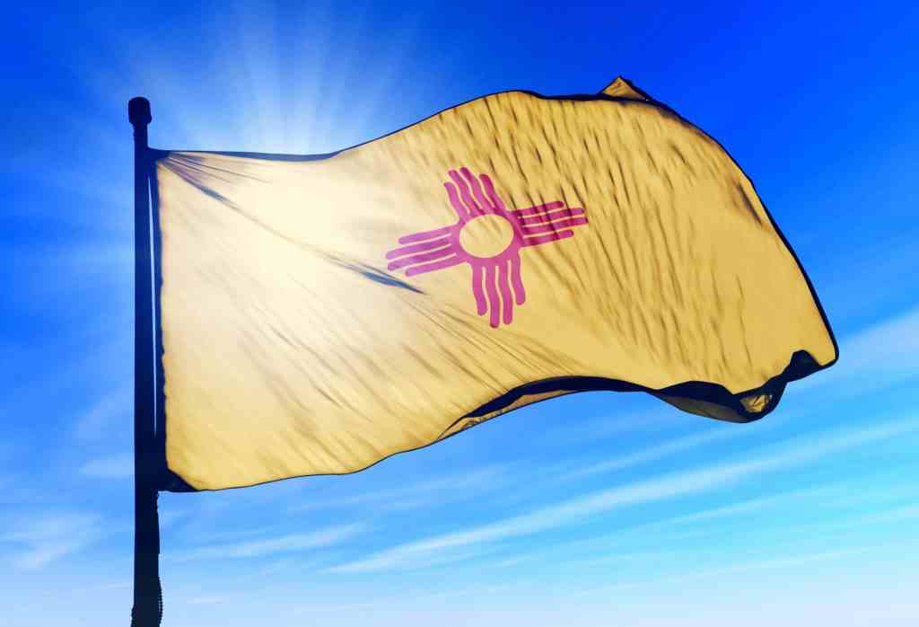
The area that is New Mexico was claimed by Spain in the 16th century, became part of Mexico in 1821, and was ceded to the United States in 1848, through the Treaty of Guadalupe Hidalgo. The New Mexican flag, which is among the most recognizable in the US, reflects the state’s eclectic origins, bearing the scarlet and gold coloration of the Spanish flag, along with the ancient sun symbol of the Zia, a Puebloan tribe.
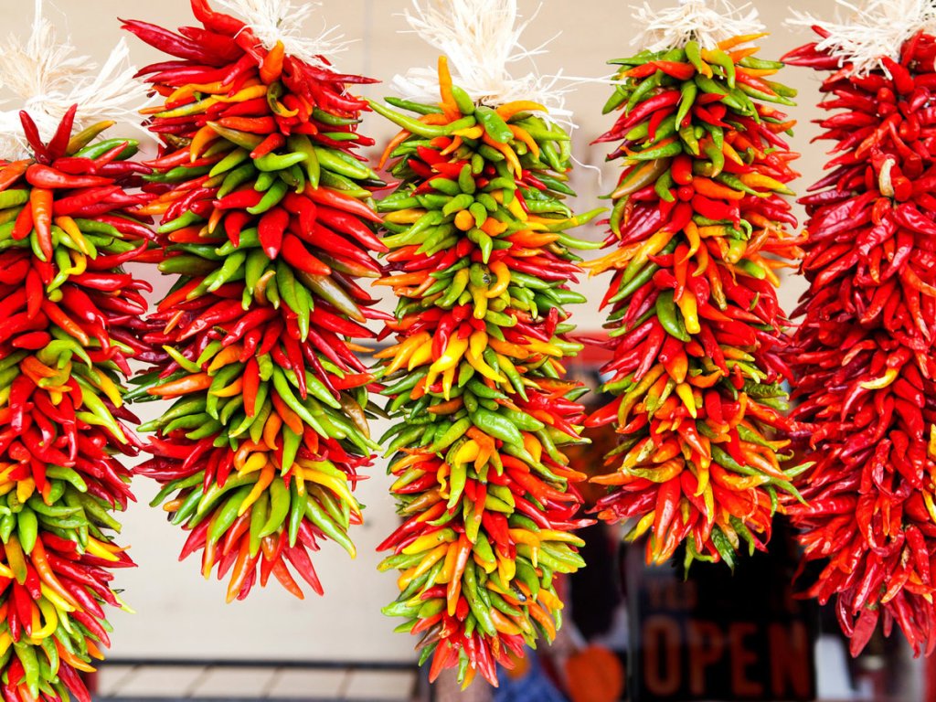
The Land of Chile
New Mexico license plates are easy to spot, with their distinctive red and green chiles. “Chile Capital of the World,” proclaims the license plates. The green chile has become the state’s icon. For you spelling fanatics, chile with an “e” refers to a hot pepper. Chili with an “i” is a dish that mixes chile peppers with other ingredients. In British English, the preferred spelling for the pepper is chilli. The various spellings are unique to different geographic locations.
For hundreds of years, New Mexicans have perfected the art of growing chiles. The hot peppers were first introduced in 1598, when the conquistador Don Juan Onate brought crops from Mexico, including chiles, that had never been grown in the region before.
Over time, ancestral Puebloans adopted these new crops and made them an essential part of their diets. Today, New Mexico has roughly 8,400 acres of chile planted; the state’s chile production is said to be worth about $55 million annually. Following a long season of hot days and cool nights, the chiles are harvested from early August until the end of September. The hub of the chile growing takes place along the Rio Grande River, in the Hatch Valley – between Truth or Consequences and Las Cruces.
Chama, New Mexico, population 1,000, seems like a good place for a fuel-and-cool stop. Chama sits at 7,860 feet in the Northern New Mexico Rocky Mountains.
Leaving Chama, we continue south, then east, following the Chama River. Eventually, we wind our way through the Brazos Mountains, a range that’s part of the Tusas Mountains.
Thirty miles from Chama, we arrive at Brazos Summit, the highest paved pass in New Mexico. At 10,528 feet, it’s the seventh 10,000-foot pass we’ve crossed on this trip. Nearby Brazos Peak stretches to 11,294 feet.
It’s about a 25-mile descent, dropping 2,500 feet, from Brazos Summit to the tiny community of Tres Piedras, Spanish for “Three Rocks.” Tres Piedras sits at about 8,000 feet.
You know you’re in Tres Piedras when you see the old railroad water tower, a relic of the days between 1880 and 1941, when the village was a stop on the narrow-gauge Chili Line railroad. The Chili Line was part of the Denver & Rio Grande Western Railroad; it was nicknamed the Chili Line because of its freight, which prominently featured New Mexico chile peppers.
In Tres Piedres, we continue our journey east on US Highway 64, which brings us to a major tourist attraction, the bridge across the Rio Grande Gorge. Known locally as the “Gorge Bridge,” it’s one of the highest in the US Highway system – about 600 feet above the Rio Grande River.
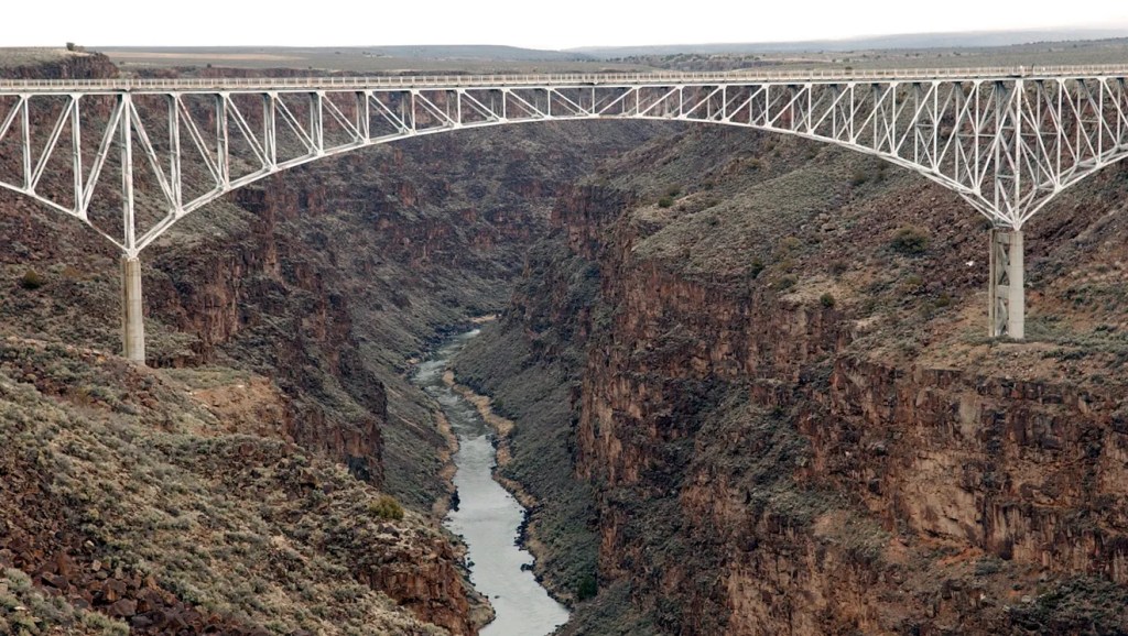
After its dedication in 1965, the American Institute of Steel Construction (yes, there is such a thing) awarded the bridge “Most Beautiful Steel Bridge” in the “Long Span” category.”
The photogenic bridge has appeared in several films, including Natural Born Killers, Terminator Salvation, and Wild Hogs. In Wild Hogs, John Travolta, Tim Allen, Martin Lawrence and William H. Macy – in a posse much like ours – are heading to a New Mexico chile festival, when they ride across the bridge.

The bridge, rated the number one tourist attraction in the Taos area, is also a good background for a wedding. It’s a great non-traditional, non-churchy location.
From the Gorge Bridge, it’s only 12 miles west of Taos, tonight’s destination.
But we’re not yet ready to call it a day.
Just a few miles north of Taos, we decide to join the Enchanted Circle Scenic Byway, a 60-mile loop around Wheeler Peak and the Taos Ski Valley. The Enchanted Circle Scenic Byway is the seventh byway we’ve ridden on this trip, and certainly not the last. New Mexico has long been known as The Land of Enchantment, a nickname the state came up with to promote tourism. So, it’s only fitting that this designated scenic byway be called the Enchanted Circle.
Enchanted Circle Byway
The byway’s a two-hour detour, but well worth taking. It’s said to be New Mexico’s top motorcycle road. Why not?
We turn north on New Mexico Highway 522, our start of the Enchanted Circle Scenic Byway. On the byway, we’re riding a clockwise loop around Wheeler Peak. The 13,167-foot mountain is the highest peak in New Mexico. It’s just two miles from the ski slopes of Taos Ski Valley, which can only be accessed from the city of Taos.
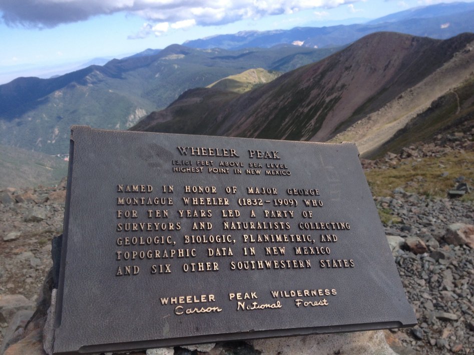
Formerly named Taos Peak, it was renamed Wheeler Peak in honor of Major George Montague Wheeler. For ten years – mostly in the 1870s – he led a party of surveyors and naturalists, collecting geologic, biologic, planimetric and topographic data in New Mexico and six other southwestern states. Wheeler attended the US Military Academy at West Point, where he graduated sixth in his class in 1866.
The first civilization we come to is Questa, a village of 1,800 that’s near the confluence of the Red River and the Rio Grande. Originally named San Antonio del Rio Colorado, Questa was renamed in 1883 when a US postmaster called it “Questa.” The postmaster mis-spelled the name, as it should have been spelled “Cuesta,” the Spanish name for “ridge.” Despite the error, the village has kept the name. One name the postmaster didn’t change was for the village’s historic church, the San Antonio del Rio Colorado (Saint Anthony of the Colorado River).
In Questa, we turn east on New Mexico Highway 38, continuing our circle around Wheeler Peak, in the Sangre de Cristo Mountains. Sangre de Cristo is Spanish for “Blood of Christ.” The name refers to the red-tinted hues observed during sunrise and sunset.
The resort town of Red River, once a mining hotbed, is ahead. The town is home to the Red River Ski & Summer Area, which calls itself “New Mexico’s Real Deal.” It’s a family-owned resort that sits at 8,750 feet. You can buy a season pass for $545, about 20 percent of the cost of a pass at Colorado’s major resorts. Or, in what may be the best deal ever – if you’re over 70, or under 5, you can get a season pass for $20. Seriously, $20!
A few miles east of Red River, we cross 9,820-foot Bobcat Pass. It’s named for the frequency of bobcats in the area. Bobcat is a year-round haven for outdoor lovers. Cowboy activities and off-roading in the summer, snowmobiling in the winter.
Just past Bobcat Pass, our circle bends south, and we approach the village of Eagle Nest. With a population of about 300, Eagle Nest is primarily a summer home and resort destination. Once known as Therma, the village adopted the name of Eagle Nest after the completion of the nearby Eagle Nest Dam and Lake in 1920.
As we continue circling Wheeler Peak, the Scenic Byway begins to turn west. Fifteen miles past Eagle Nest, we arrive at Palo Flechado Pass, also called Taos Pass. The 9,109-foot pass has been used historically for travelers making their way from the eastern plains to Taos, by way of the Cimarron River.
Palo Flechado is Spanish, meaning tree pierced with arrows. The name originated from the Flecha de Palo band of Apaches, based on a Taos Indian custom of shooting arrows into a tree at a mountain pass following a successful buffalo hunt.
We’re now following the Fernando de Taos River.
Finally, Taos
The Enchanted Circle Scenic Byway twists and turns, as we begin a gradual 2,000-foot descent into Taos, elevation 6,969 feet. The circle closes in Taos, as we enter town on tree-lined Kit Carson Road.
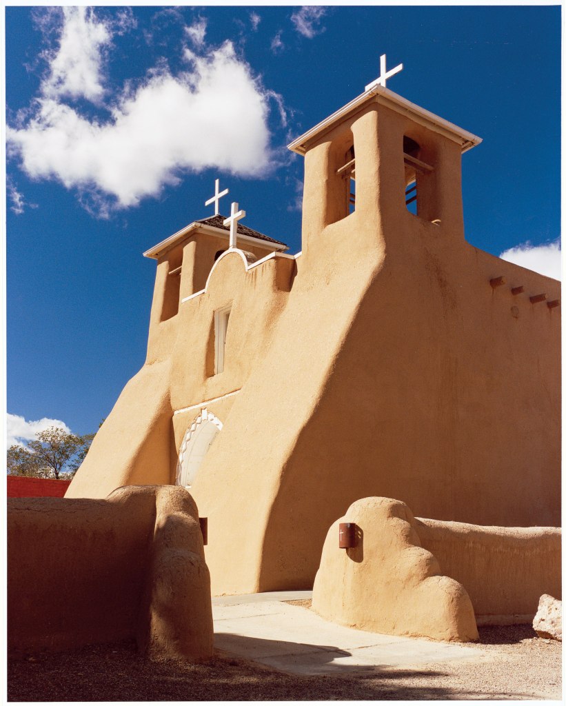
With a population of about 6,600 – almost identical to Carbondale’s – Taos is known for its art colonies and adobe architecture. The Taos Pueblo is a World Heritage Site. The town’s St. Francisco de Asis church is iconic; its images are seen all over the world.
Taos was initially founded in 1615, then formally established by Nuevo Mexico Governor Fernando Chacon to act as a fortified plaza and trading outpost for the neighboring Taos Pueblo and Hispano communities. The town was incorporated in 1934.
The name Taos derives from the Taos language, meaning “place of red willows.”
Taos, population 6,600, is known for its arts scene. There are three museums in town, and several local venues for the performing arts.
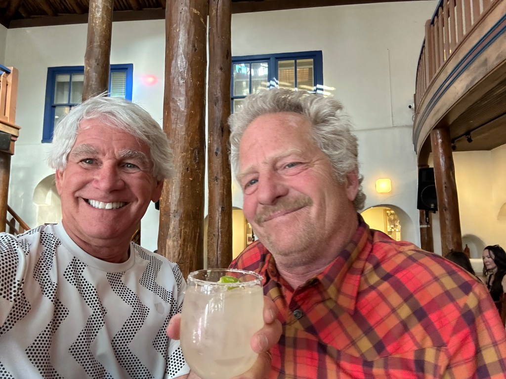
We – the four of us on motorcycles – are not known for our interest in arts – at least while on a motorcycle trip. So, we end our journey on the Enchanted Circle, and roll in to the Historic Taos Inn, tonight’s lodging. Good travel planning is when we don’t have to leave the hotel for dinner; it’s a strategy that minimizes DUI opportunities, and just makes the evening go better.
Tonight is one of those nights. We’re eating at Doc Martin’s, inside the hotel, mere steps from our rooms. The food is authentic southwestern cuisine that celebrates New Mexico’s culinary roots.
Thomas Paul “Doc” Martin was a doctor who was one of the first American residents of Taos County, and the first practicing physician in Taos. After graduating from medical school in Maryland, he moved to Taos in 1890, and was a major figure in the development of Taos.
Following his death in 1935, Martin’s widow Helen converted his adobe home into the Hotel Martin, which opened a year later. Subsequent owners renamed it the Taos Inn, and following its inclusion on the National Register of Historic Places in 1982, it became the Historic Taos Inn – our home for the night.
Did someone just set a Margarita in front of me? Must be time for dinner. We’re dining at Doc Martin’s.
***
The Day in Review:
Click here to see today’s complete route from Durango, Colorado, to Taos, New Mexico – via the Enchanted Circle Scenic Byway.
Today’s Takeaways:
- Chiles, a New Mexico staple.
- Cruising the Enchanted Circle.
- Doc Martin, a Taos pioneer.
Today’s Trivia: Taos Pueblo
The name Taos was borrowed from a Spanish word meaning “village.”
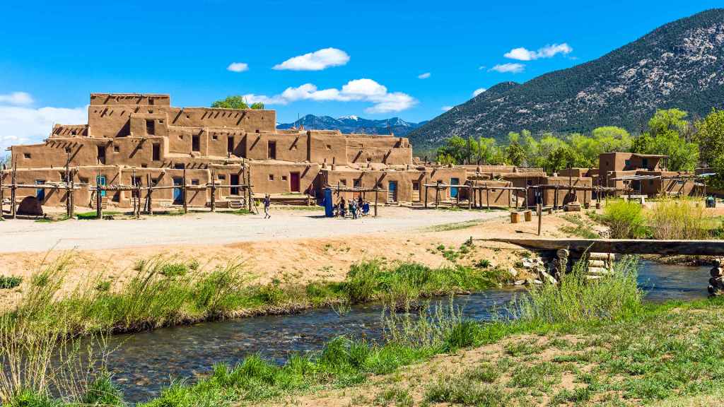
The most famous sight in Taos is the Taos Pueblo, an ancient village two miles north of town.
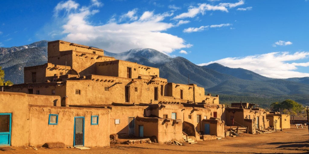
The Taos Pueblo is about 1,000 years old, and is home today to 150 people who live in the traditional manner – no electricity or running water. It’s one of the oldest continuously inhabited communities in the US. The Pueblo is owned and administered by the Taos Tribal Council.
Archaeologists have found evidence that the Taos Valley has been inhabited as far back as 3000 B.C. and prehistoric ruins dating from 900 A.D. can be seen throughout the area. However, the Taos Pueblo is thought to have been built between 1000 and 1450 A.D. and appears today much as it did a millennium ago, linking today’s Native Americans with those early inhabitants of years ago.
Taos Pueblo is the only living Native American community designated both a World Heritage Site by UNESCO and a National Historic Landmark.
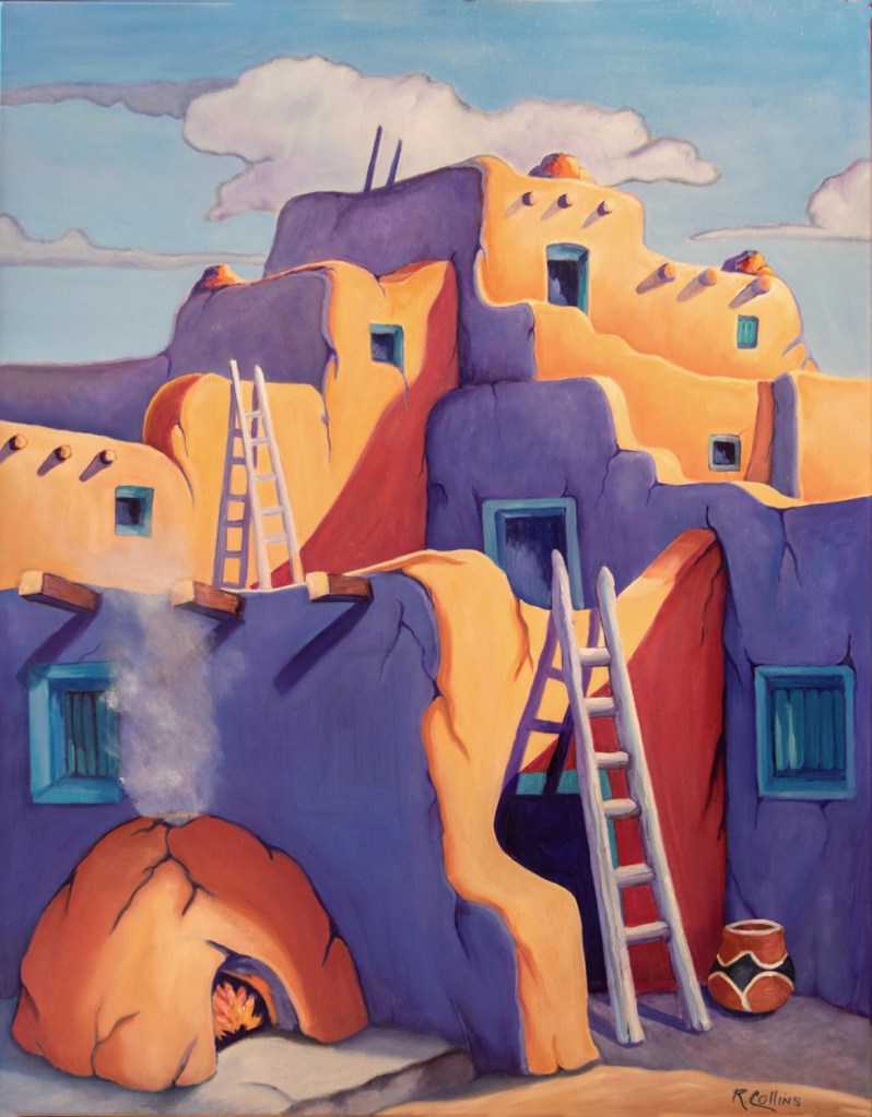
The Taos Pueblo is considered a remarkable example of a traditional type of architecture, from the pre-European period of the Americas. It sits atop of a list of “10 Homes That Changed America,” recognized for design that has stood the test of time. The building is seen as a model for locally sourced, climate-conscious design and building methods. Most homes in the Taos Pueblo have ladders leaning on a front wall. The ladders were used to enter the homes in the days before they had doors.
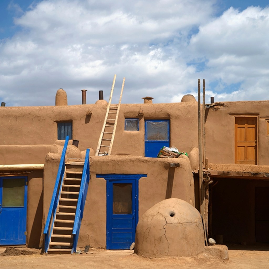
Two-foot thick, load-bearing adobe walls on the lower levels support the pueblo’s upper floors. This load-bearing building design remained the standard for tall buildings for hundreds of years, even for the earliest tall buildings constructed of brick in cities like New York and Chicago. The roofs of each of the five stories at the Taos Pueblo are supported by vigas – large timbers hauled down from the mountain forests.
The Taos Pueblo’s most prominent architectural feature is a multi-storied residential complex of reddish-brown adobe. Like many ancient dwellings, it is actually many individual homes, built side by side and in layers with common walls but no connecting doorways.
The Taos art colony was founded by artists attracted by the culture of the Taos Pueblo. The Pueblo was the subject of the famed photographer Ansel Adams’ first book. It’s said to be one of the most photographed and painted buildings in North America.
This pueblo was one of the first communities in the American Southwest that Spanish explorers visited. It played a central role in the cultural struggles that permeated the Southwest throughout the 16th, 17th and 18th centuries. After the Spanish arrived, the community embraced certain Spanish and Catholic traditions, but remained suspicious and even hostile toward the Spanish colonists themselves.
The pueblo is open daily to visitors most of the year. For $16, you can get a glimpse of how life has been lived for hundreds of years, and still is today. It’s one of the most popular tourist attractions in New Mexico, and throughout all of the Southwest.
And now you know.

You know I love your rides. The photos of you all having fun are great.
LikeLike
You don’t have a picture where I don’t look as old as I am? Thanks for mention. It looks like a beautiful ride.
LikeLike
Gary, nice write up, as usual. I lived in New Mexico for four years while attending UNM in Albuquerque. With respect to the delicious chiles, you missed the classic New Mexico question, “red or green?”
LikeLike