With Rebel BBQ a tasty memory, and sadly, not open for breakfast, we leave California and point three Harleys toward Arizona.
Heading east from Blythe, I-10 leads us across the Colorado River, which forms the California-Arizona border. Halfway across the bridge, we cross into Arizona – the second of nine states on this trip – and blow by the border town of Ehrenberg. About all you can say for Ehrenberg is that its gas is way cheaper than California’s.
After Ehrenberg, Quartzsite is the first town we come to. It’s best known for gem shows and swap meets during the winter. Quartzsite, which calls itself the “Rock Capital of the World,” is a haven for RVs, and attracts more than a million people annually, mostly in January and February. It’s exactly halfway between La Quinta and Phoenix.
As we pass by Quartzsite, we’re 125 miles from Phoenix. But we won’t get as much as a whiff of Arizona’s largest city (1.5 million), and the fifth-most populous in the US. Eleven miles east of Quartzsite, we turn northeast on US Highway 60 and begin heading toward Arizona’s mountains.
The area is desolate, except for an occasional RV park, rundown motel, or bar. In tiny Salome, the biggest news in decades was a triple homicide in April 2016.
US-60 is straight, flat, and quite boring as we work our way toward Aquila. To our right are the Harquahala Mountains, the highest range in southwestern Arizona. The zenith, Harquahala Peak, rises to 5,691 feet.
The Bureau of Land Management controls the Harquahala Mountains Wilderness Area, nearly 23,000 acres of chaparral, desert grasslands and rare cactus.
The BLM says you need a high-clearance four-wheel drive vehicle to get to the boundary of the wilderness area. That pretty much leaves us out, so we press on.
In Aquila – whose highlights include a gas station called Woody’s, the Burro Jim Motel, and a Family Dollar store – we turn north on Arizona Highway 71. The road takes us through Congress, which is little more than a convenience store, and into the mountains toward Yarnell.
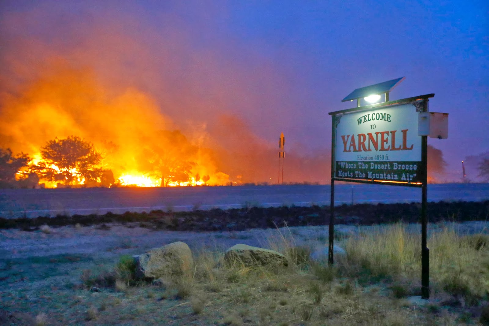
Tragically, Yarnell was made famous in 2013 by the Yarnell Hill wildfire that destroyed half the town and killed 19 firefighters from nearby Prescott. The firefighters, who died trying to save the town, were part of the elite Granite Mountain Hotshots. A Hollywood movie about the Yarnell Hill fire, called “Granite Mountain,” is set for release in September. It stars Josh Brolin, Andie MacDowell, Jennifer Connelly and Jeff Bridges.
***
We’re now on Arizona Highway 89. It’s 35 miles to Prescott. The last 16 miles, beginning in Wilhoit, are steep and curvy as we ride through the Prescott National Forest.
Prescott is a mountain city of 40,000, sitting at 5,368 feet in the Bradshaw Mountains. It was designated in 1864 as the capital of the pre-statehood Arizona Territory. With many Victorian-style homes, Prescott, which has 809 buildings on the National Register of Historic Places, calls itself “Everybody’s Hometown.”
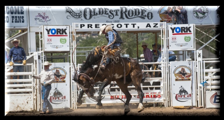
Known for its western and cowboy feel, Prescott annually hosts Frontier Days, which was featured in the 1972 Steve McQueen film Junior Bonner, and claims to be the world’s oldest rodeo. Prescott also has an annual Bluegrass Festival held at its historic Courthouse Plaza. Bands at previous festivals include The Sonoran Dogs, The Mars Hillbillies, and Marty Warburton and Home Girls.
Prescott has earned a number of designations and distinctions, including being named Arizona’s Christmas City in 1989 by then Governor Rose Mofford, “a Preserve American Community” in 2004 by First Lady Laura Bush, and one of “a Dozen Distinctive Designations” in 2006 by the National Trust for Historic Preservation.
Prescott even has a Harley store, Grand Canyon Harley Davidson. They sell clothing and chachkas, but not motorcycles.
***
Next stop, Jerome – a historic mining town at 5,066 feet elevation, sitting between Woodchute Mountain and the Mingus Mountain Recreation Area.
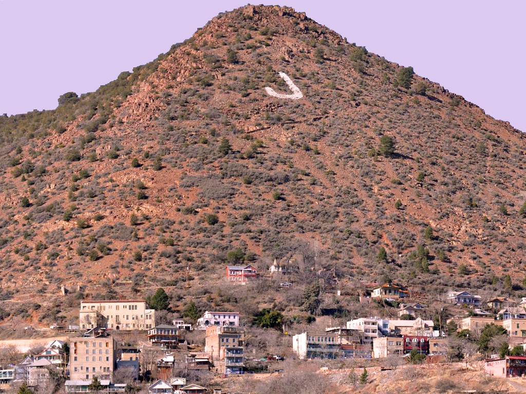
The twisty ride into Jerome is spectacular, especially the last 10 miles. Jerome was named for Eugene Murray Jerome, a New York investor in the early mining operations on Cleopatra Hill, which dominates Jerome’s horizon. A prominent “J” is still visible on Cleopatra Hill.
Supported in its heyday by rich copper mines, Jerome was once home to 15,000 people. Today, its population is less than 500, but it’s big enough to have its own website, which says Jerome was once known as the wickedest town in the west.
Jerome sits above what was once the largest copper mine in Arizona, producing three million pounds of copper every month. As the ore deposits became exhausted in the 1950s, the mines closed and Jerome took on a new persona. It became a National Historic Landmark in 1967, and today is an art community, with coffee houses, wineries, and a local museum devoted to mining history.

Jerome’s funky, artistic vibe attracts musicians, writers, and plenty of tourists, who walk its narrow, winding streets.
***
From Jerome, we descend steeply toward the town of Cottonwood, which may be most notable for its huge collection of traffic circles on Highway 89A. There are six of the roundabouts in a four-mile stretch. Who was the traffic engineer that dreamed this up?
Just north of Cottonwood is the Tuzigoot National Monument, which preserves a three-story pueblo ruin on the summit of a limestone and sandstone ridge overlooking Clarkdale. Tuzigoot is Apache for “crooked water,” a reference to nearby Pecks Lake and the Verde River.
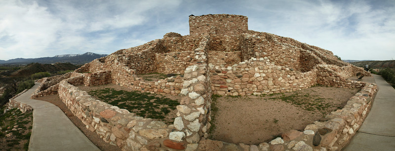
Tuzigoot was excavated in the 1930s by archaeologists from the University of Arizona, with funding from the Civil Works Administration and Works Project Administration. President Franklin Roosevelt designated the Tuzigoot Ruins as a National Monument in 1939. Tuzigoot is one of 122 National Monuments; 18 of the 122 are in Arizona, more than any other state.
We continue north on Arizona Highway 89A toward Sedona, which calls itself “The Most Beautiful Place on Earth.” No argument there.
Regarded by Native Americans as sacred, Sedona is recognized as a place of healing and spiritual renewal. Many visitors come to experience the vortex energy centers, whatever those are. There’s a specialized New Age tourist industry here. If you’re a believer, spiritual vortices are concentrated in the Sedona area at Bell Rock, Airport Mesa, Cathedral Rock and Boynton Canyon.
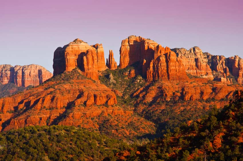
Sedona is surrounded by red-rock buttes, steep canyon walls and pine forests. There’s a lot of kitschy tourist stuff here, but not nearly enough to overshadow its unparalleled natural beauty.
Sedona, which sits at 4,326 feet, is best known for its array of red sandstone formations. The city of 10,000 was named after Sedona Arabella Miller Schnebly, the wife of its first postmaster. Her mother claimed to have made up the name Sedona because “it sounded pretty.”
The name is pretty, the city is spectacular, but we’re not quite ready to park the bikes.
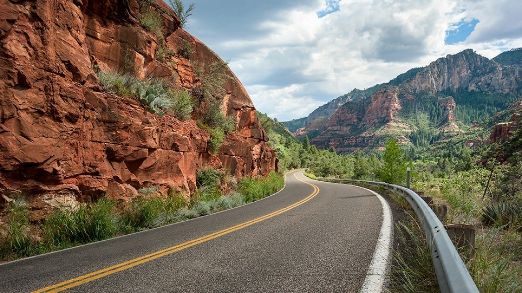
So, we leave Sedona behind, and head north on Arizona Highway 89. The road is immediately awesome. For about 25 miles, until we get to Flagstaff, we’re on a two-lane road that winds through Oak Creek Canyon and past Slide Rock State Park.
The road has some spectacular switchbacks, beautiful scenery and breathtaking vistas. Oak Creek Canyon Scenic Drive is recognized as one of the top five scenic drives in the US, by Rand McNally, and is considered one of the best motorcycle roads in Arizona.
The scenic drive climbs 4,500 feet from Sedona to the top of the Mogollon Rim.
As the road straightens out, we approach Flagstaff, home to Northern Arizona University. We pass the Flagstaff Pulliam Airport, whose runway is at an elevation of 7,014 feet. American Eagle is the only airline serving Flagstaff, flying Canadair CRJ-200 regional jets.
Near the airport, we jump on Interstate 17 for a few miles, then I-40 East for five miles, before continuing north on US Highway 89.
These highways replaced Route 66, which was known as the Main Street of America until the US Interstate highway system was built, and sadly made Route 66 irrelevant and obsolete. Roads in Flagstaff are still marked as Historic Route 66. Route 66 was officially decommissioned in 1985, but parts of it can still be found stretching across the desert. In Arizona, Route 66 once covered 401 miles, the most of any state.
Route 66 was one of the original highways in the US Highway System. It was established in 1926, a 2,448-mile roadway connecting Chicago with Santa Monica, California. Also known as the Will Rogers Highway, Route 66 ran through Missouri, Kansas, Oklahoma, Texas, New Mexico, Arizona and California. The – inspiring the TV show Route 66 and the song of the same name (“Get Your Kicks on Route 66!”).
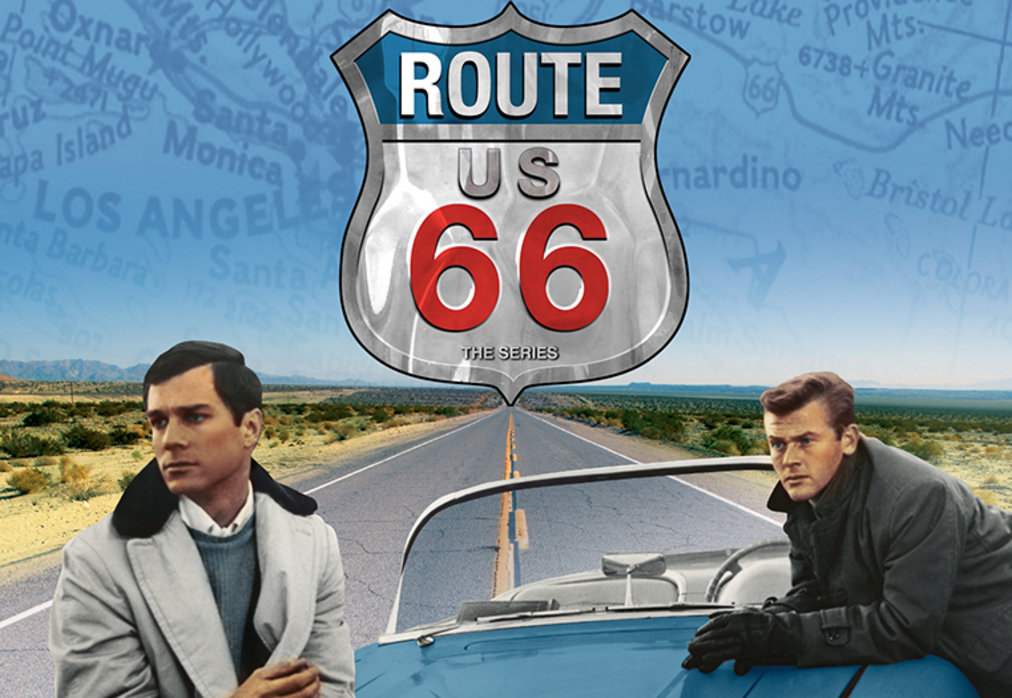
Route 66 was once a major path for Americans migrating west. In his Pulitzer Prize-winning 1939 novel, “The Grapes of Wrath,” John Steinbeck called Route 66 the “Mother Road,” because it beckoned and delivered the refugees from the Dust Bowl exodus to jobs in California.
The Mother Road leads us to today’s destination, Flagstaff, elevation 6,909 feet, whose motto is “Service at a Higher Elevation.” We park our bikes for the night, grab a healthy dinner, and contemplate a long day in the hot sun tomorrow.
***
Day Two Summary: Two hundred fifty miles, beginning in California and climbing more than 7,000 feet into Arizona’s mountain ranges, seeing the most beautiful place on earth, and Everybody’s Hometown.
Click here to see today’s complete route from Blythe to Flagstaff.
We’re on our way to Sturgis!
Vroom, vroom.
***
Today in Bucket List History:
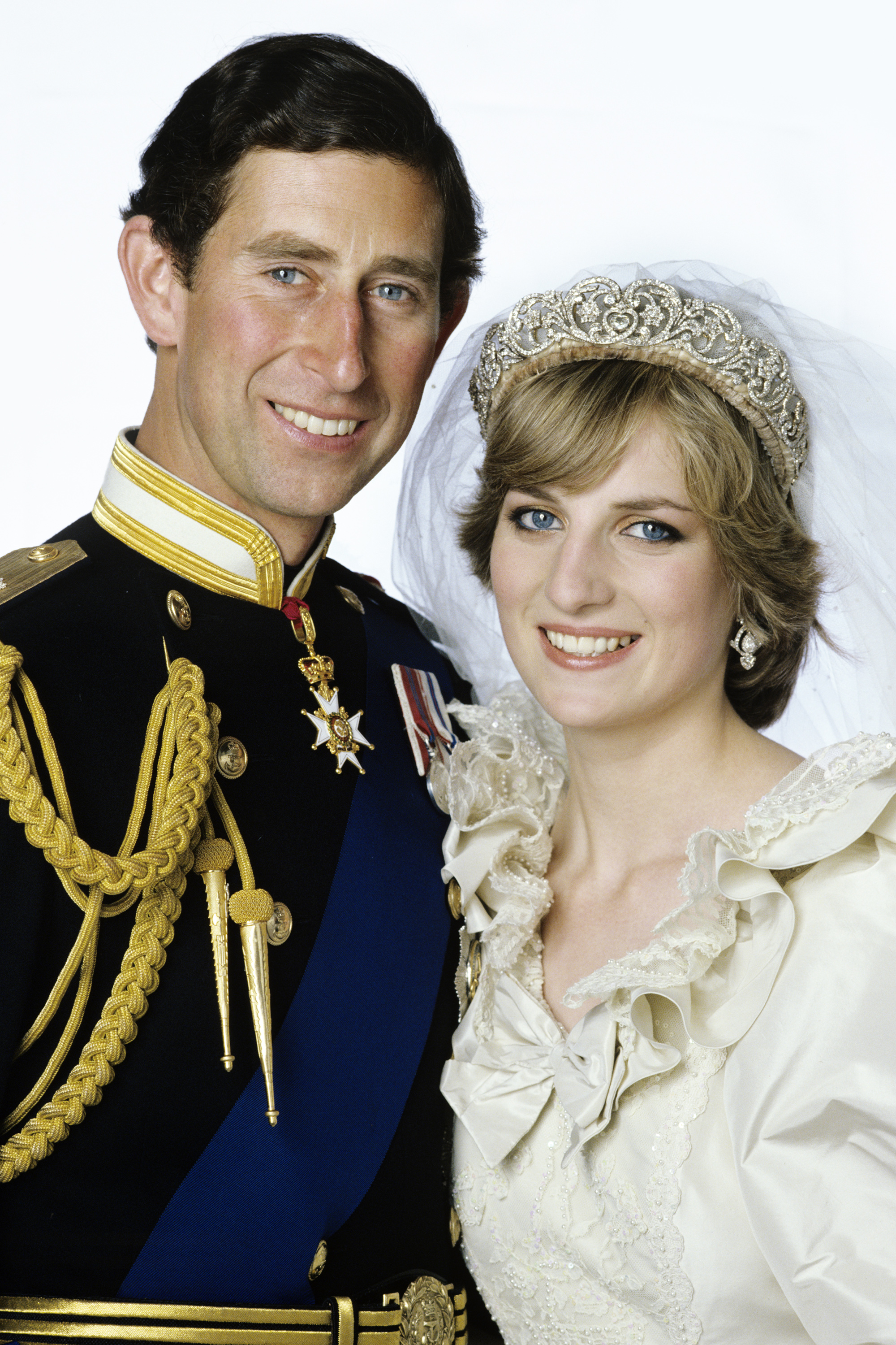
Bucket List Goal: “Have a Splashy Wedding That Gets Lots of Attention.”
Goal Achieved: On July 29, 1981, Prince Charles of Wales and Lady Diana Spencer are married at St Paul’s Cathedral in London in a ceremony seen by a global TV audience of 750 million. The United Kingdom has a national holiday that day to mark the wedding.
What’s on your bucket list?

So happy to follow along. Can’t belive you didn’t give a shout out to my Sedona yoga reatreat eith the wonderful Stephen Kaleda in October . See y’all then:-)
LikeLike
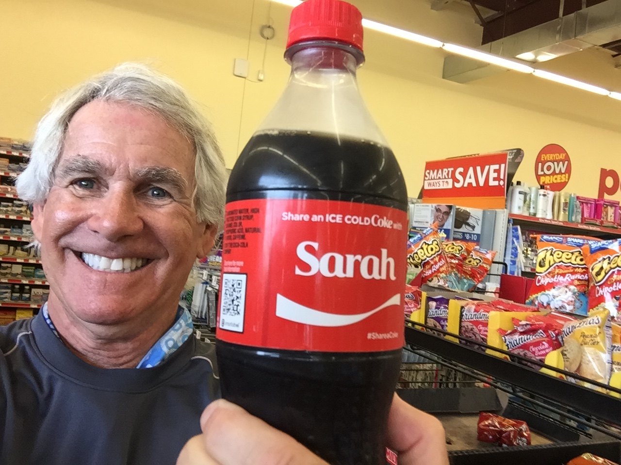
Can’t believe YOU didn’t give a shout out to my skin-cancer-preventing SPF 50 sun sleeves, and especially my Sarah-branded hydration 🙂 OK, OK, everybody. The wonderful Stephen Kaleda is having an awesome yoga retreat in Sedona in October. It’s sold out, so good luck getting in.
LikeLike
Fun to read. Been to so many of these places when I was a kid. Thx for the memories.
Ride safe,
Mama Bear
LikeLike
Thanks, Mama Bear. I remember hearing about all those “stuff the Caldwell kids in the station wagon trips” that you loved so much growing up. Glad I could rekindle the memories, even if only for a short time. Bon Voyage on your next trip, which I assume begins in a few days (it always does). Imagine you and Stevie are not taking the station wagon with Glee in tow.
LikeLike
Great pics guys. Love northern AZ. “Rubber side down”
LikeLike
Not too late to join us, Bob!
LikeLike
Love your idea of a “healthy meal”! Peace out!,
LikeLike
All health food, all the time!
LikeLike
All health food, all the time! Peace. Out.
LikeLike
It all takes me back to my college days at ASU and the multiple times I visited almost all of those places. My parents had a corner lot in Sedona looking at Coffeepot but, alas, never built on it. This was a sentimental reprise for me. Thanks, Gary!
LikeLike
Glad to provide a sentimental journey for you, Paula.
LikeLike
You coulda been a play-yuh in Sedona, Paula!
LikeLike
Last time I was in Sedona it was for our anniversary. I took Jo up in. Bi-plane for a ride through the red hills.
She wasn’t happy because she thought it was going to be lots of acrobatics. But I pointed out it is so we can fly slow and low. She loved that!!
LikeLike
Where’s Jo when we need her?
LikeLike
One time in Sedona I went to a vortex. Didn’t one back till 1983. Weird!
LikeLike
THE Kathy Lynwood? Man, thus is like a KOMO alumni reunion!
LikeLike
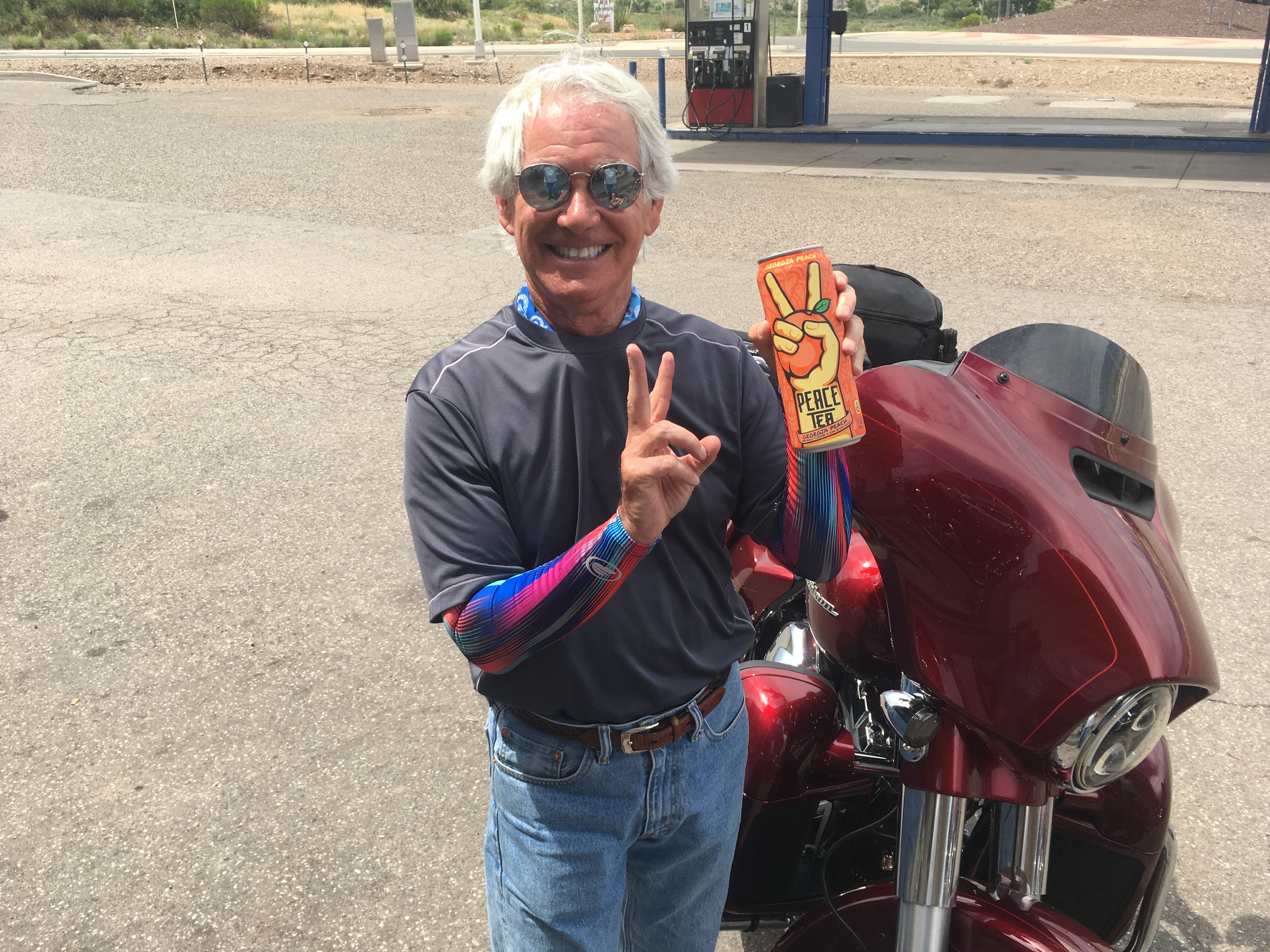
WE noticed your sun sleeves AND the Sarah coke bottle!! Also, noticed the ribs, beer, etc. We are jealous since coming home from vacation and on diets -ugh!
Hope you are cooling off a bit by now. Have to admit I (Barb) never heard of Sturgis so will be excited to see all the motorcycles. BTW do you need ear plugs driving through Sturgis with all the noise?
We always look forward to where you are in your trip.
J&B
LikeLike
Thanks for ending on a royal note! I just want to correct your grammar: the U. K. HAD a national holiday that day but do not commemorate it now. In fact not even mentioned in royal circles as horse face took Princess Diana’s place! Their wedding was not a cause for a National Celebration but kept rather low key. Her boys on the other hand did an HBO documentary this year (highly recommended for its honesty and emotional revelations – very un British and royal like): Princess Diana, Her Life and Legacy. Jude the Brit.
LikeLike
Gary great route and I have traveled that route a number of times and Jerome and Prescott are just wonderful as is Sedona and all the red rocks and hills. We did a jeep trip out in the hills of Sedona which was just wonderful and am sure your next leg will be very nice.
LikeLike