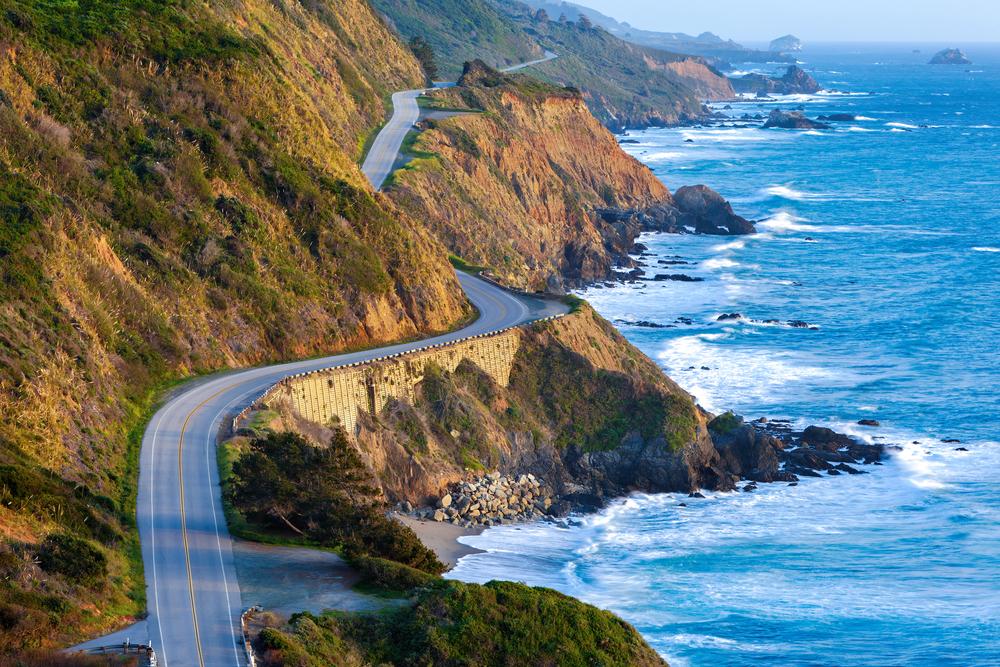
Today, we ride one of the top five motorcycle roads in America: Highway 1 between San Simeon and Carmel. This twisting, cliff-hugging route has been designated an All-American Road. More accurately, it’s all-world! A true bucket-list ride.
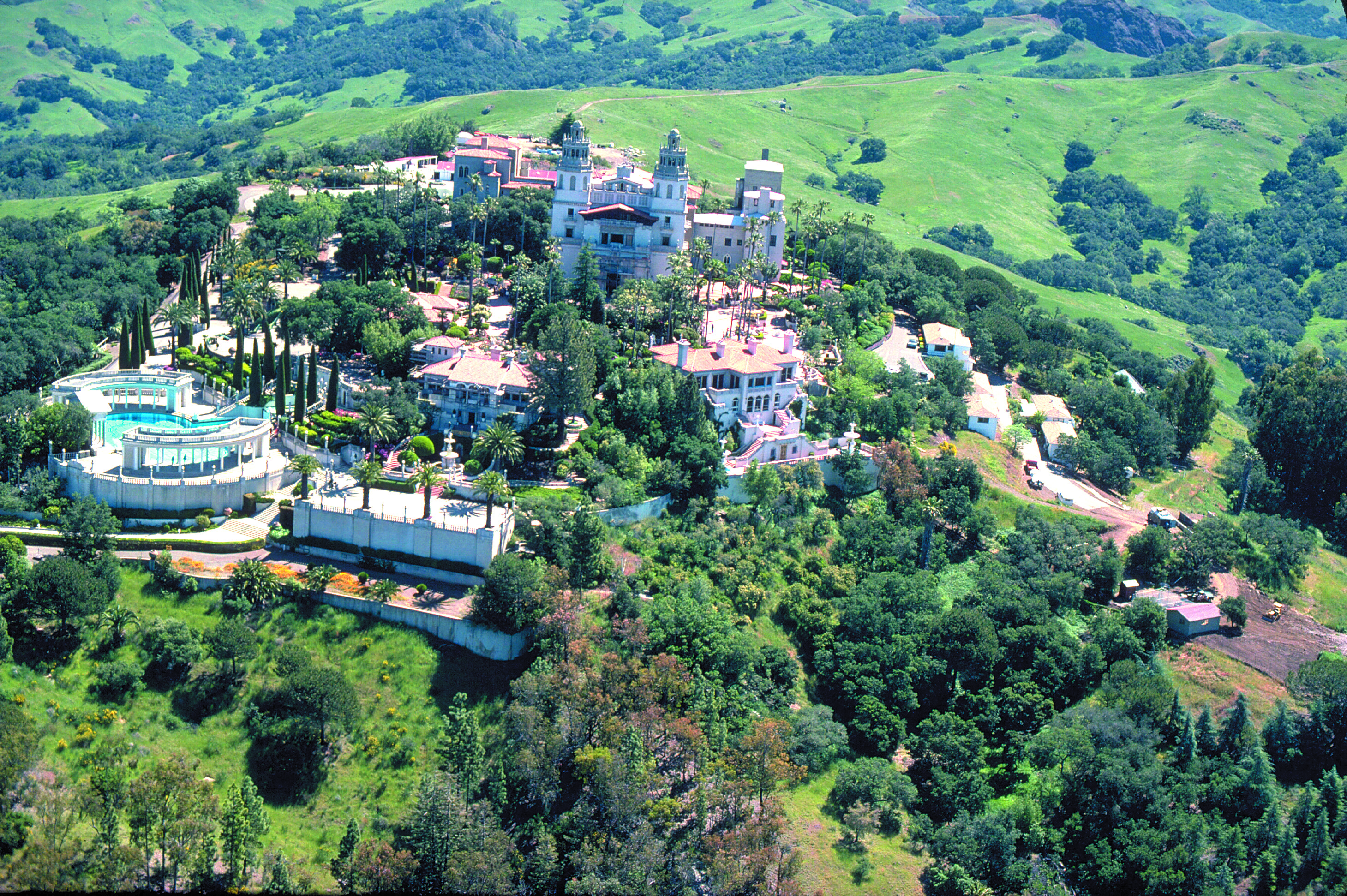
After breakfast in Cambria, it’s 10 miles on Highway 1 to San Simeon, best known for the Hearst Castle, an ostentatious reminder of the days when there was big money to be made in newspapers. The castle was the brainchild of newspaperman William Randolph Hearst. It’s now a National and California Historic Landmark, and is part of the California State Park System.
The castle sits atop a hill of the Santa Lucia Range at an elevation of 1,600 feet. Casa Grande, the main building on the castle grounds, is 60,645 square feet. Including several “smaller” buildings on the grounds, the castle features 56 bedrooms, 61 bathrooms, indoor and outdoor swimming pools, a movie theater, an airfield, and the world’s largest private zoo. Nice life.
Here’s a high def video tour of the castle, much cheaper and less time consuming than actually going there.
You could spend all day at the Hearst Castle. Or you could ride a Harley to Big Sur.
We point six wheels northward and opt for Big Sur.
Soon, the road climbs steeply and the views increase dramatically. It’s stunning.
We pass the Piedras Blancas Light Station on a point supposedly named in 1542 by Juan Rodriguez Cabrillo for its rocks stained white with bird droppings. Piedras Blancas means white rocks. Early mariners used the large white offshore rocks as navigational landmarks.
In 1875, a light station was established to aid maritime navigation. The lighthouse still sends a white flash every 10 seconds to assure mariners of their location and warn them of the rocky coastline. The light station today is operated by the Bureau of Land Management, and managed as an historic park and wildlife sanctuary.
Continuing north, there’s nothing but mile after mile of breathtaking vistas. It’s hard to focus on the road, and not the view.
Building this highway was no small accomplishment. The state and Federal governments appropriated funds in 1921 and the road from San Simeon to Carmel was completed in 1937, built for around $10 million – in 1930 dollars. Construction was handled by inmates from California’s San Quentin Prison, who were paid 35 cents per day and had their sentences reduced in return.
We are doing this ride pro bono – literally, for the public good. No charge. You’re welcome.
***
Eventually we arrive in Big Sur.
Big Sur’s relative isolation and natural beauty has attracted writers and artists, including Henry Miller (Tropic of Cancer), Richard Brautigan (Trout Fishing in America), Hunter S. Thompson (Fear and Loathing in Las Vegas) and Jack Kerouac (On the Road).
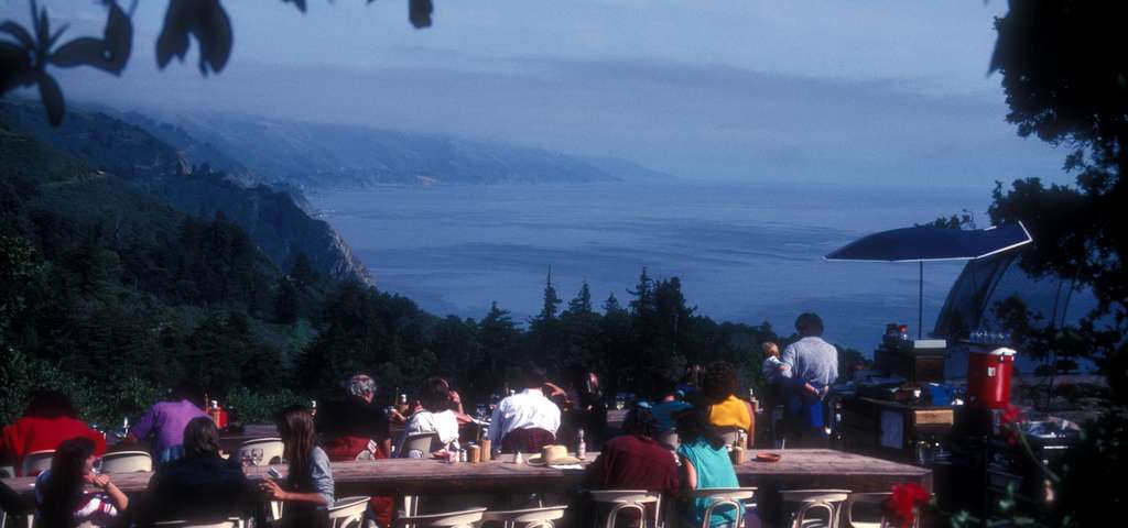
The area’s increasing popularity in the 1950s and ’60s brought the attention of Hollywood celebrities. Orson Welles and his wife at the time, Rita Hayworth, bought a Big Sur cabin on impulse during a trip down the coast in 1944. They never spent a single night there, and the property is now the location of a wildly popular restaurant, Nepenthe.
Thirsty and Hungry? A Nepenthe Bloody Mary is $11, a Castroville Artichoke appetizer $11.50, Nepenthe Steak $41.50, Minestrone Soup $25.50, and a California Artisanal Cheese Plate for dessert $17.00. Add a couple of glasses of wine, and a generous tip — and your dinner bill for one could run you $150 or more.
Besides sightseeing from the highway, which is our approach, Big Sur offers hiking, mountain climbing and other outdoor activities. Big Sur’s Cone Peak is the highest coastal mountain in the contiguous 48 states, ascending 5,155 feet above sea level, only three miles from the ocean.
Big Sur is filled with dozens of scenic hiking trails, some climbing into the mountains with expansive views of the Pacific Ocean. For a little variety in today’s ride, we park our bikes at Julia Pfeiffer Burns State Park in Big Sur and hike the shortest trail in the area – the McWay Waterfall trail.
The trail is less than three-quarters of a mile out and back. The view of the 80-foot falls is one of the most popular images of Big Sur. The McWay Waterfall Trail gets its name from McWay Creek, which cascades onto the sandy shore below. For you travelers who enjoy hikes, the McWay Falls hike is certifiably awesome, as noted by Sunset magazine’s list of 50 Best Hikes in the West.
As short as it is, the hike provides a welcome respite from hours in the saddle.
***
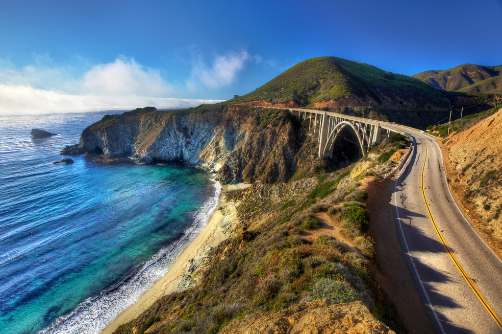
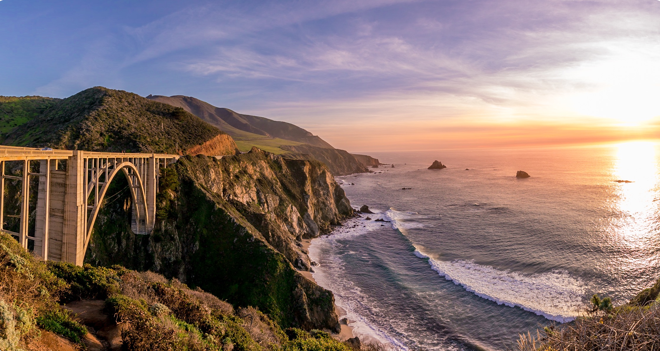
Construction of the San Simeon to Carmel road required 33 bridges, the largest of which was the much-photographed Bixby Creek Bridge, 20 miles past McWay Falls. The bridge is a single-span concrete arch more than 280 feet high and 714 feet long. When completed in 1932, it was the longest concrete arch span on the California State Highway System. Originally built for less than $200,000, it was seismically retrofitted in the late 1990s at a cost of about $20 million.
The Bixby Creek Bridge, about 13 miles south of Carmel, is one of the most photographed features on the California coast, and has been frequently used in automobile commercials and films. It was seen in the opening sequences of Play Misty for Me, and The Sandpiper.
For a drone’s eye view of the bridge, check this out; few people have seen Bixby Bridge from these vantage points!
Carmel, formally known as Carmel-by-the-Sea, is known for its natural scenery and rich artistic history. Actor-director Clint Eastwood, though a rabid-right Republican, served as the nonpartisan mayor of Carmel from 1986 to 1988.
The beach town has bountiful natural charm, enhanced by some local ordinances that keep things just right. There are no fast food restaurants in Carmel. That’s the law. The city’s municipal code also bans wearing shoes that have heels more than two inches in height, unless the wearer has obtained a permit. And, the city once prohibited the sale and consumption of ice cream on public streets. It’s a little like Singapore, which bans chewing gum – but without the tropical humidity.
***
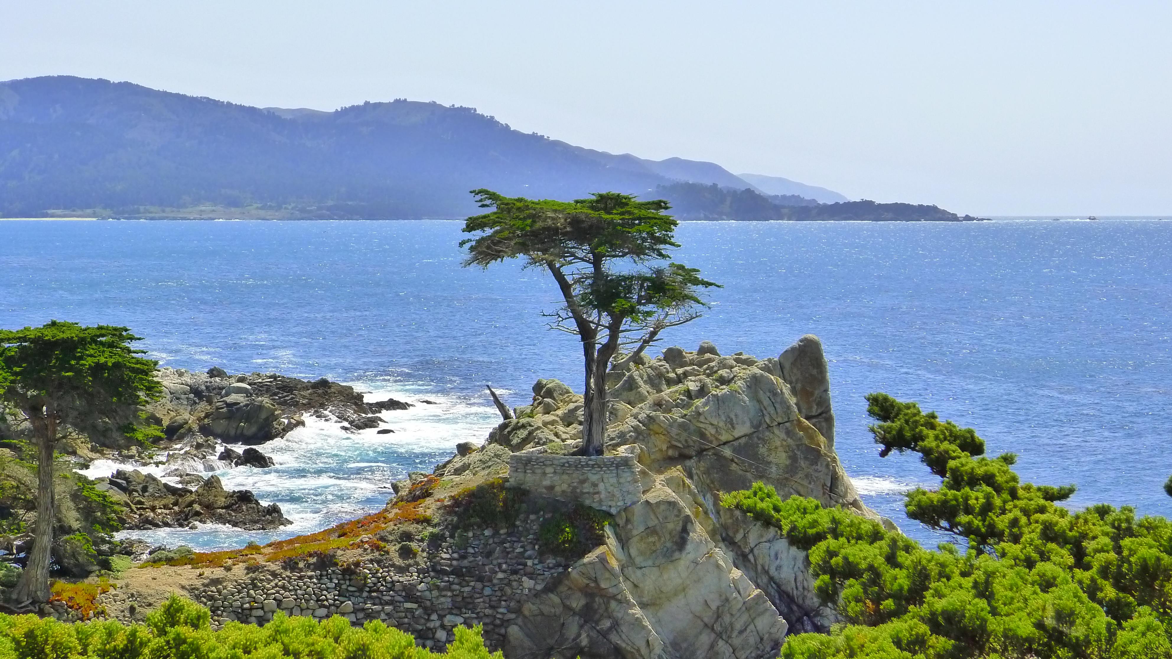
Just north of Carmel is an entrance to the world-renowned 17-Mile Drive. If you’ve ever been to Pebble Beach to play golf or have a glass of Chardonnay, you took the 17-Mile Drive to get there.
I’ve driven the 17-Mile Drive a half-dozen times over the past 50 years, and couldn’t wait to do it again. How awesome to drive past the much-photographed Lone Cypress tree on our Harleys!
Imagine my disappointment in planning this trip to find out that the 17-Mile Drive doesn’t allow motorcycles. It’s a privately owned forest, and they can allow in (or exclude) whomever they want. Damn rich people. Here’s a video showing what we would have seen on the 17-Mile Drive if we’d been allowed through the gates.
We ride on, past Carmel and Monterey, home of the world-famous Monterey Bay Aquarium, located at the site of a former sardine cannery on Cannery Row. Here, we stop for oysters, calamari, and clam chowder served in sourdough bread. After lunch, we continue north. To our left along Highway 1 is Fort Ord, a former Army post on Monterey Bay that closed in 1994. Nearly two million soldiers passed through the gates here, many as part of their infantry training.
The fort was named for Major General Edward Cresap Ord, a Union Army leader during the Civil War. As a young lieutenant, he supervised construction of Fort Ord’s predecessor, Fort Mervine, in the 1840s.
Most of the fort’s land now makes up the Fort Ord Dunes and National Monument, whose 7,200 acres have more than 86 miles of trails that can be explored on foot, bike or horseback. Fort Ord’s former military golf courses, Bayonet and Black Horse, are now public and have hosted PGA tour events.
Castroville is the next city in our sights. It’s known as the “Artichoke Capital of the World.” The annual Artichoke Festival is held at the end of May. Marilyn Monroe was given the honorary title of Artichoke Queen in 1947 during a visit to the Monterey Bay area.
In Moss Landing, our final seaside encounter of the week, we turn inland and head for Gilroy, another food-themed city.
We wind our way over the twisty Hecker Pass, Highway 152, before arriving in Gilroy, the “Garlic Capital of the World.” Gilroy holds its Garlic Festival annually in late July. The event includes a garlic braiding workshop, celebrity cooking demonstrations, and free garlic ice cream.
Amazing what a pungent bulb can do for the local economy.
***
The remainder of today’s ride – the next 100 miles or so – is what you might call transit. Nothing exciting. Just putting ourselves in a place where tomorrow’s ride will be awesome from start to finish.
The rest of the way is hot, flat, mostly straight, and quite boring.
We roll through Los Banos, Spanish for “the baths.” It’s named after a spring that feeds natural wetlands in the western San Joaquin Valley. We are a long way from the ocean, but the elevation here is barely over 100 feet. Might as well be in Kansas. It’s hot.
Next city on our transit is Merced, known as the “Gateway to Yosemite.” We skirt the heart of downtown Merced, which isn’t missing much. Property values here were flattened during the recent Great Recession. Merced suffered one of the greatest property price collapses in the country.
Leaving Merced, we’re riding east on Highway 140, the Central Yosemite Highway. Yosemite – that has a nice ring to it. We’ll soon visit the National Park that is among the most photographed of them all.
The road ever-so-gradually begins to climb, as we near the foothills of the Sierra Nevada mountains. In an hour, we arrive in Mariposa, Spanish for “butterfly.” Notable former residents of Mariposa include William Costello, original voice of Popeye the sailor; and John Fremont, first US Senator from California, first Republican candidate for president and explorer of the West with American frontiersman Kit Carson. More on Kit Carson tomorrow.
Mariposa, elevation 1,950 feet, was founded on the banks of a seasonal stream known as Aqua Fria, and was once known by that name – Aqua Fria – meaning “cool water.”
Aqua Fria or Mariposa – it doesn’t really matter. We have arrived at our destination for the day – 273 miles and seven hours of saddle time later.
Tomorrow, we begin the week by doing two states: Solid and Liquid. Or, California and Nevada.
Won’t that be interesting?
***
To view today’s route from Cambria to Mariposa, click here.
